Lympne (Portus Lemanis) Roman Port
Claudian Auxiliary Fort (AD 43–54) and Port
Portus Lemanis, which was also referred to as Lemanae, was an important Roman Saxon Shore fort, settlement, and port located in the southern region of Kent. The present-day village of Lympne gets its name from this ancient port. The site is locally known as Stutfall Castle.
Not one of the original Claudian bridgeheads, but possibly an important safe-harbour on the perilous journey along the South coast of Britain to Isle of Wight (Vectis Insvla) and the Claudian port at Chichester (Noviomagus Reginorum). Also further round the coast to the Cornish Tin-mining centre at St Michael’s Mount0(Ictis Insula). The ancient iron-mining district of the South Downs lay to the west of the port, and it is possible – though not proven – that these industries were administrated from Dover nearby.
Early Roman fort at at Lympne
The first fort at Lympne was a naval base for the Classis Britannica. We believe this as tiles stamped CL BR have been found indicating that sailors or marines of the fleet were involved in its construction.
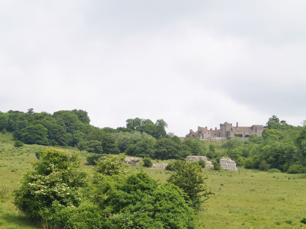
The assumed coastline during Roman times would have allowed the fort at Lympne to protect the entrance of a substantial natural harbour in an area now part of Romney Marsh.
An altar stone was found in one of the gate towers, where it had been used as infill during the construction of the second fort (Saxon Shore fort). This stone, which had for some time been in the sea, due to it’s being discovered encrusted with salt water barnacles, would indicate that it was from a previous building, probably the first fort or maybe Portus Lemanis?
RIB 66 - Altar dedicated to Neptune
To Neptune, Lucius Aufidius Pantera, prefect of the British Fleet, (set up this) altar.
ARAM
L AVFIDIVS
PANTERA
PRAEFECT
CLAS BRIT
For L. Aufidius Panthera see CIL iii p. 1978 = CIL xvi dipl. 76, Stein in PIR² no. 1391. Starr dates this about a.d. 135.
The ‘Saxon Shore’ Fort at Lympne
The surviving remains you can see today belong to a fort of the Saxon Shore and belonging to the period c.AD 270.
Lympne (Fig. 11c) is to-day chiefly remarkable for its ruined condition; huge fragments of its walls lie scattered at various angles, many yards away from their original positions, owing to the slipping of the wet clayey ground. The walls are 14 feet thick and stand in places 23 feet high ; they have tile bonding-courses and cylindrical bastions with chambers inside them. The main gate is 11 feet wide, with projecting towers, and there are several posterns. The shape is an irregular pentagon and the area between 9 and 10 acres.” (Collingwood, p.53)
Slightly to the south west of the gate the remains of a bath house (balneum), were pointed out, although there is nothing visible.
The present fort appears to have been abandoned c.350 on the basis of coin and pottery evidence. There is, however, a reference in the Notitia Dignitatum c.395 to a garrison of the numerus Turnacensium but this is not thought to be realistic and is possibly an error (see below).
Entries in the Classical Geographies
The Roman name for the Lympne fort is first mentioned in the Antonine Itinerary in the late-second century. The Fourth Itinerary of this work is entitled “the route from Londinium to the port of Lemanis – sixty-eight thousand paces”. The entry Portus Lemanis is listed in Iter IV sixteen miles from the cantonal capital of Cantium at Durovernum (Canterbury, Kent).
Lympne next appears in the Notitia Dignitatum of the late-fourth century, under the direct command of “the Count of the Saxon Shore in Britain”. In this document, the entry for Lemannis is listed between the entries for the other Saxon Shore forts at Dover (Portus Dubris) and Brancaster (Branodunum) Roman Fort. The full N.D. entry is shown below.
The last classical geography to mention the Saxon Shore fort at Lympne is the Ravenna Cosmology (R&C#70) compiled in the seventh century. This document records the name as Lemanis between the entries for Dover and an unidentified station named Mutuantonis.
The Military Units of Lemannis
Numerus Turnacensium – The Company of Turnacenses
Praepositus numeri Turnacensium, Lemannis
“The Leader of the Company of Turnacenses at [Portus] Lemannis.”
(The Notitia Dignitatum xxviii.15; 4th/5th C.)
Later History of Lympne (Portus Lemanis)
During the 13th century, a castle was built on a plot of land that overlooked the Roman ruins. Despite its strategic location, the castle was never utilized in any military campaigns, and it gradually fell into disrepair over the centuries. However, during the First World War, the castle was repurposed as a military barracks.
In more recent times, the castle has played host to several notable musicians. In fact, Paul McCartney’s band, “Wings,” used the castle as a recording studio to create their album “Back to the Egg.” Other famous musicians, such as Led Zeppelin, Pink Floyd, and The Who, have also used the castle as a recording studio. Despite its varied history, the castle remains a popular destination for tourists, who come to admire its architecture and explore its past.
Visitng Lympne (Portus Lemanis) Roman Port
There is not much to see apart from the surviving bits of walls at strange angles and moved by gravity from their original positions.
Access to the archaeological site of Portus Lemanis is restricted due to its location on private property. However, visitors can still enjoy stunning views of the ruins from a public footpath that runs alongside the area. Park at the car park for the Royal military canal This path also offers glimpses of the nearby Roman ruins, which are separated from the enclosures of several animal species that belong to the Port Lympne Zoo. It’s worth noting that the castle is only open to the public on specific days each year, so visitors should check the website for details.
The best part of walking along this footpath is the opportunity to see incredible animals such as giraffes, wild dogs, and black rhinos for free. These animals are housed in enclosures adjacent to the Roman ruins, and visitors are asked not to feed them. In addition to the fascinating wildlife, visitors can also enjoy the breath-taking view of the surrounding countryside and coastline.
References for Portvs Lemanis
- The Cantiaci by Alec detsicas (Sutton, London, 1987);
- The Romans in Britain – An Anthology of Inscriptions by A.R. Burn (Blackwell, Oxford, 1969);
- The Roman Inscriptions of Britain by R.G. Collingwood and R.P. Wright (Oxford 1965);
- Air Reconnaissance of Southern Britain by J.K. St. Joseph in J.R.S. xliii (1953) pp.81-97;
- The Archaeology of Roman Britain by R.G. Collingwood (1930).
Map References for Portvs Lemanis
NGRef: TR1134 OSMap: LR179/189
Roman Roads near Portvs Lemanis
N (14) to Dvrovernvm Possible Coastal Road: W (8) to Folkestone (Kent) Probable Road: SW (36) to Hastings (East Sussex) WNW (26) to Maidstone (Kent) Trackway: ENE (13) to Portvs Dvbris (Dover, Kent)
Sites near Lympne (Portus Lemanis) Roman Port
- Folkestone Villa (12 km)
Villa - Dover (Portus Dubris) Classis Britannica Fort (20 km)
Auxiliary Fort - Dover (Portus Dubris) Roman Port (20 km)
Pharos, Vicus and Villa - Bigbury Camp (23 km)
Iron Age Hillfort - Canterbury (Durovernum) Roman Fort (23 km)
British Capital, Claudian Auxiliary Fort (AD 43–54) and Oppidum - Canterbury Roman Museum (23 km)
Museum - Ospringe (Durolevum?) (29 km)
Minor Settlement - Worth Temple (29 km)
Temple Or Shrine - Durolevum (Faversham?) (29 km)
- Richborough (Rutupiae) Roman Fort (32 km)
Port and Saxon Shore Fort