Richborough (Rutupiae) Roman Fort
Port and Saxon Shore Fort
This important fort was erected at the point where the first landings of the Claudian invasion were made in 43AD, and was to form the original bridgehead, supply base and safe harbour. Sometime around 85AD the original wooden buildings were replaced in stone, and a huge 4-way triumphal arch known as a quadrifrons erected. This structure was over 10 metres high, faced with fine marble and decorated with bronze statues. It is possible that this monument was also adorned with a copy of an inscription found at Rome which records the surrender of eleven British kings to the emperor Claudius (CIL VI.920).
By the end of the third century the arch had been dismantled and a 2 hectare Saxon Shore fort with eight metre high walls constructed around it. The bath-house of the Saxon Shore fort was built over the remains of an earlier Mansio or imperial posting house. The construction methods and styles used in the Saxon Shore forts of Britain during the late-3rd century were based on those developed in Gaul to protect provincial towns from barbarian invasion.
Entries in the Classical Geographies
The early second century geographical treatise by Claudius Ptolemaeus assigns three towns to the Cantiaci tribe of Cantium; the tribal capital at Durovernum Cantiacorum (Canterbury, Kent), the provincial capital at Londinium (London, Greater London) and the town of Ritupie, now known as Richborough near the eastern Kentish coast.
Opening Passage of the Iter Britanniarum
“From Gesoriacum¹ in Gaul to Ritupiae the port of Britannia. A total of four-hundred and fifty stadia.²”
- Gesoriacum is now equated with the northern French port of Boulogne.
- The ancient Greek measure of a stadium (plural stadia) equates with a distance of 607 feet (184 metres). The total reported distance between the two ports would therefore be 51¾miles (c.82.8 km). The modern measurement is closer to 45 miles (c.65 km).
The late-second century Antonine Itinerary mentions Richborough twice, the first time in the opening passage of the Iter Britanniarum shown above, also in Iter II within the body of the document, entitled “the route from the ‘entrenchments’ to the port of Ritupiae“, and details the Roman road stations from Hadrian’s Wall to Richborough. In Iter II the distance between Portus Ritupiae and the penultimate station Durovernum (Canterbury) is recorded as 12 miles, which agrees favourably with the modern measure.
The Richborough entry in the Notitia Dignitatum of the late-4th/early-5th century appears as Rutupiae between the entries for Regulbium (Reculver, Kent) and Anderitum (Pevensey, East Sussex). In addition, Richborough appears in the seventh century work, the Ravenna Cosmology (R&C#73), also as Rutupiae, but this time between the entries for Durovernum Cantiacorum (Canterbury) and Durobrivae (Rochester, Kent).
It is thought that the name Rutupiae is derived from the ancient Welsh/Gaelic for ‘muddy waters’ or ‘muddy estuary’.
Romano-British Temples at Richborough
Romano-British Temples 1 & 2
This pair of square shrines is located 350 yards south of the fort. Both of these temples probably faced east-south-east, were both built around 300AD and fell into disuse later in the 4th century:
- Temple 1 to the north, measures 40 feet by 39 feet across its portico, with a cella 19½ feet square; all walls were about 3 feet thick. (Type I)
- Temple 2 to the south, had a portico measuring 46 feet by 43 feet, with a cella 23½ feet by 22 feet; all walls were fairly substantial, between 3¼-4 feet in thickness, with the interior cella wall slightly the thicker. (Type I)
Suspected Classical Temple – Site 4
Situated just west of the cruciform quadrifrons base are the foundations of a building measuring about 16½ ft. wide by 21 ft. in length, with an extension on the east which possibly represents the facade of a small temple. It is thought to have been built around the same time as the Saxon Shore fort. Fragments of a Venus-like figurine have been recovered from the area of this building which would seem to confirm that it was, indeed, a small tutelary temple to the goddess.
The Garrison Units of Rutupiae
RIB 62 - Fragmentary inscription
64
No commentary.
The Rutupiae Entry in the Notitia Dignitatum
“The prefect of the Second Augustan Legion at Rutupiae“
The Second Augustan Legion are the only garrison unit mentioned in the classical sources, and were stationed here sometime toward the end of the fourth century, after having spent the majority of their stay in Britain within the Legionary fortress at Caerleon in South Wales.
The Richborough Fortifications
The Claudian Bridgehead
The surviving length of the western ditch is 2,100 feet (640 m) and includes the south corner angle. It is possible that the defences continued northwards for some 400-500 feet, and, assuming that the enclosure was rectangular in outline, this would give an internal area of around 140 acres (57 ha). No post-holes or structures were found within the enclosure, which suggests that the troops were housed in field conditions (i.e. in tents, papillae). There was a gate-tower in the western defences, but these were quickly levelled to make way for an even larger timber-built stores depot. This sequence of events is consistent with that of an initial disembarkation camp, followed by a large military supply depot. It should be noted that this sequence is not recorded at Chichester, also, the triumphal arch was later erected here at Richborough, and not at the postulated landing-site in Sussex.
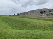
The Saxon Shore Fort
Richborough (Fig. 12a) seems to have been originally planned as a square fort about 500 feet each way externally, or about 5 1/3 acres if (as seems to be the case) there was no earth bank inside the walls. But before completion it was elongated to between 550 and 580 feet, making it over 6 acres. The walls are 11 feet thick, and in places still stand 25 feet high. The corners are angular, not rounded; and there was probably a gate in each end and a postern concealed in a bastion in each side. The corner bastions are cylindrical, the others rectangular; the existing gate, 11 feet wide, was flanked by projecting towers. Excavation shows that there were two ditches, reinforced near the gateway by a third ; and the date of construction is in the last quarter of the third century (Richborough Excavation Reports, i and ii ; Society of Antiquaries).” (Collingwood, p.51)
References for Rvtvpiae
- The Cantiaci by Alec detsicas (Sutton, London, 1987);
- The Church at Richborough, by P.D.C. Brown, in Britannia ii (1971) pp.225-231;
- The date of the Construction of the Saxon Shore Fort at Richborough by J.S. Johnson in Britannia i (1970) pp.240-248;
- Temples in Roman Britain by M.J.T. Lewis (Cambridge 1966);
- The Roman Inscriptions of Britain by R.G. Collingwood and R.P. Wright (Oxford 1965);
- Air Reconnaissance of Southern Britain by J.K. St. Joseph in J.R.S. xliii (1953) pp.81-97;
- The Archaeology of Roman Britain by R.G. Collingwood (London 1930). T
Map References for Rvtvpiae
NGRef: TR325602 OSMap: LR179
Roman Roads near Rvtvpiae
Watling Street: W (11) to Dvrovernvm S (12) to Portvs Dvbris (Dover, Kent) S (3) to Worth
Sites near Richborough (Rutupiae) Roman Fort
- Worth Temple (5 km)
Temple Or Shrine - Westgate Villa (8 km)
Villa - Tanatus (Isle of Thanet?) (9 km)
- Reculver (Regulbium) Fort (13 km)
Saxon Shore Fort - Canterbury Roman Museum (17 km)
Museum - Canterbury (Durovernum) Roman Fort (18 km)
British Capital, Claudian Auxiliary Fort (AD 43–54) and Oppidum - Dover (Portus Dubris) Roman Port (19 km)
Pharos, Vicus and Villa - Dover (Portus Dubris) Classis Britannica Fort (19 km)
Auxiliary Fort - Bigbury Camp (21 km)
Iron Age Hillfort - Folkestone Villa (25 km)
Villa


