Dobunni territory initially comprised northern Wiltshire and southern Gloucestershire, the locations of the earliest coin distributions. The tribe later expanded into western Oxfordshire, northern Gloucestershire, north-eastern Somerset, Avon, parts of Hereford and Worcester, and also South Warwickshire.
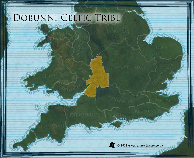
It has been suggested that they were little more than a division of the Atrebates, and only gained independence during the reign of the pro-Roman Tincommius in the late first century BC. If this was the case then the Dobunni were probably an earlier people who had been pushed out of their territory by the arrival of the Atrebates, and subjugated along the way.
By the first century (circa 35 BC) the Dobunni borders abutted those of the Atrebates, and the coinage of both tribes seems to be found in parallel. The suggestion is, once again, that the Atrebates were overlords of the Dobunni. However, the Dobunni ejected the Romanised Atrebatean coins which appeared from 30/20 BC and began producing their own coins, suggesting a claim of independence. By AD 20/25, the Dobunni also found themselves bordering the powerful Catuvellauni, although they seem to have been on friendly terms with this powerful tribe.
“Next to these [the Silures] are the Dobuni, and their town Corinium 18*00 54°10”
The Realm of the Dobunni according to Geographia of Ptolemy (II.ii)
Unlike the Silures, their neighbours in what later became south east Wales, they were not a warlike people and submitted to the Romans even before they reached their lands. Afterwards they readily adopted the Romano-British lifestyle. Even though the Dobunni were incorporated into the Roman Empire in AD 43, their territory was probably not formed into Roman political units until AD 96-98. The tribal territory was divided into a civitas centred on Cirencester, and the Colonia at Gloucester.
What does the name Dobunni mean?
The meaning of the name is unclear but their original name may have been “Bodunni”, connected with the Celtic word *bouda meaning “Victorious”, in the sense of “The Victorious Ones”. The name Boudica is also linked to this word meaning victory.
Another meaning may come from the original Irish / Gaelic word. The current spelling of the name ‘Dobunni’ may of come from the Roman pronunciation of the original word, the original of which may have been ‘Dubh’. ‘DUBH’ pronounced “Doo” which means, dark or black-haired in Irish / Gaelic.
‘BUNAITHE’ “Boo-Nee” = established OR
‘BUNAICH’ “Boo-Nee” = establish, found, set (up), start. OR POSSIBLY,
‘BUNADH’ “Boo-Na” = people, inhabitants AND
‘BUNAIOCH’ “Boo-Na’ = primitive
‘Dobunni’ would mean the Dark-haired ones established this place.
Dobunni Towns and Hillforts
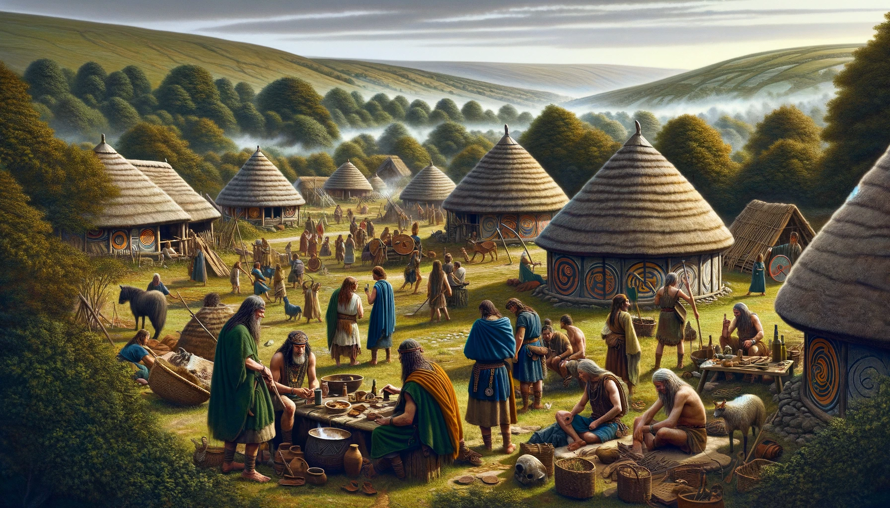
They were a non-Belgic people occupying impressive hillforts with some Belgic influences. Generally the people lived in small villages and farmed the fertile land.
The Civitas Dobunnorum The Principal Tribal Centre
Corinivm Dobvnnorvm (Cirencester, Gloucestershire)
Established by the Romans at the centre of a network of local roads, at it’s height the town covered more than 230 acres and was the second largest in Roman Britain. The only town ascribed to the tribe by Ptolemy, it is possible that it later became the provincial capital of Britannia Prima.
Other Sites of Importance
- Alcester (Warwickshire) – Small walled town.
- Ariconivm (Weston-under-Penyard, Hereford & Worcester) – A major settlement and administrative centre of the iron mines in the Forest of Dean.
- Asthall (Oxfordshire) – Minor settlement on Akeman Street, between Corinium and Alchester.
- Bagendon (Gloucestershire) – Notable oppidum-style pre-Roman settlement near Corinium.
- Blackwardine (Hereford & Worcester) – Minor settlement near border with the Cornovii in the north of the canton.
- Bourton on the Water (Gloucestershire) – Major settlement on Fosse Way NE of Corinium.
- Chesterton-on-Fosse (Warwickshire) – A small walled town near the border with the Coritani in the NE of the canton.
- Cricklade (Wiltshire) – Minor settlement on Ermin Way SE of Corinium.
- Dorn (Gloucestershire) – Romano-British town on Fosse Way NE of Corinium.
- Dvrocornovivm (Wanborough, Wiltshire) – Major settlement on Ermin Way between Corinium and Calleva Atrebatum (Silchester, Hampshire) near the border with the Atrebates.
- Glevvm (Gloucester, Gloucestershire) – The site of at least two large Roman fortresses, a Roman colonia was established here in 97AD.
- Hereford (Hereford & Worcester) – Possible Roman settlement or posting station.
- Lower Lea (nr. Swalcliffe, Oxfordshire) – minor settlement near borders with the Catuvellauni.
- Magnis (Kenchester, Hereford & Worcester) – Small town where a milestone of emperor Numerian was found, suggesting that the Civitas Dobunnorum held sway also on the west bank of the Severn. Separated from the civitas capital Corinium by the territorium of the Roman colony at Glevum, it is possible that Kenchester was the centre of an administrative pagus.
- Nettleton Shrub (Wiltshire) – Rural temple on the Fosse Way between Corinium and Aquae Sulis (Bath), marking the border between the Dobunni and the Belgae.
- Salinae (Droitwich Spa, Hereford & Worcester) – Major town whose important salt industries were worth guarding by the setablishment of an Auxiliary fort.
- Stretton Grandison (Hereford & Worcester) – Minor settlement and auxiliary fort.
- Sutton Walls (Hereford & Worcester) – Iron Age hill fort continued to be occupied by a small community into Roman times.
- Tiddington (Warwickshire) – Minor industrial settlement.
- Vertis (Worcester, Hereford & Worcester) – Town and potteries on the east bank of the Severn, at an important strategic crossing.
- White Walls, nr. Easton Grey (Wiltshire) – Minor settlement on the Fosse Way SW of Corinium.
- Wilcote (Oxfordshire) – Cluster of villas and possible settlement on Akeman Street, near the border with the Catuvellauni.
Industries
The iron mining district around Monmouth in the Forest of Dean, was administrated from Weston-under-Penyard. Salt production was maintained throughout the Roman period at natural brine springs in Droitwich Spa. There was a cluster of brick, tile and pottery kilns near Malvern at Leigh, Howsell and Upper Sandlin. There are numerous extremely rich villas in the area of Cirencester (Corinium Dobunnorum), a notable example being Chedworth, which includes a Romano-British temple.
Known Border Shrines
- Nettleton Shrub (Wiltshire) – Marking the border with the Belgae.
- Frilford (Oxfordshire) – On the frontier with the Atrebates.
- Woodeaton (Oxfordshire) – On the borders with the Catuvellauni.
Other Romano-British Temples
- Lydney (Gloucester) – Rural 4th century shrine of Nodens with bath-house and guest-accommodation, built inside an old Iron-Age hillfort on the north-west side of the Severn Estuary, possibly in deference to the ‘Severn Bore’, a tidal phenomenon of the Severn Estuary.
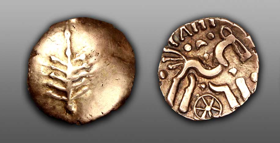
Dobunnic Tribal Leaders
Anted[…]- Dobunni King
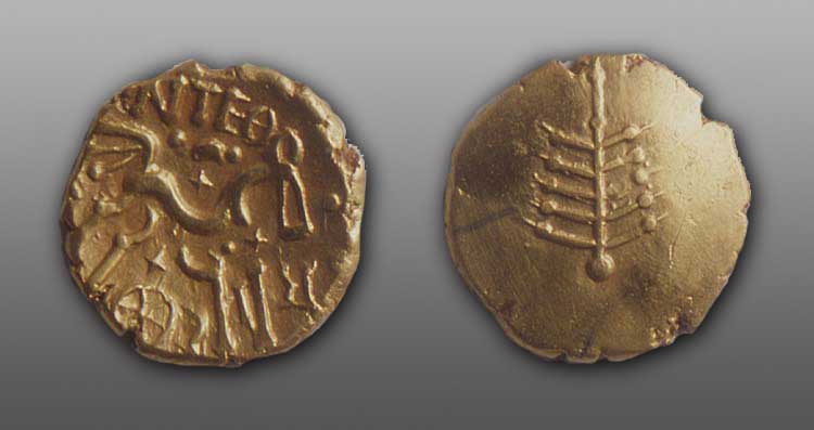
Iron age gold stater of the Dobunni Tribe. On one side there is a tree-like emblem with ten branches, while the other shows a celtic style horse with a chariot wheel below. The legend reads [ANTED] RIG.
Leader of both north and south Dobunnic territories during the first decades of the first century AD. He seemed to have brought together the northern and southern factions of the tribe under a single banner for the first time since the division of the tribe in the latter half of the first century BC, during the conflict between Bodvoc and Corio. This division was seemingly promoted by their respective successors Catti[…] and Comux[…]. Anted[…] of the Dobunni appears to have been succeeded by another single Dobunnic monarch, Eisu[…], possibly his own son, c.30AD.
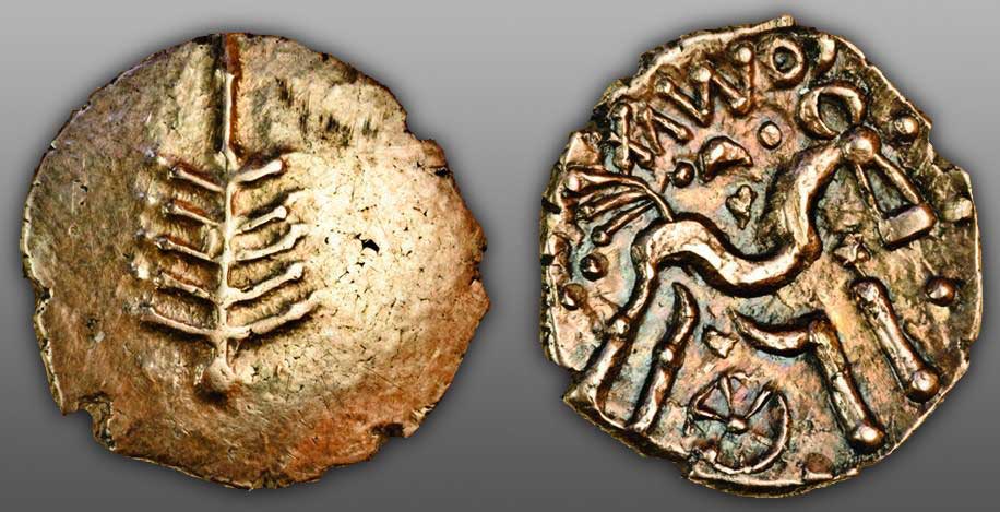
Eisu[…] (c.30AD) – Dobunni King
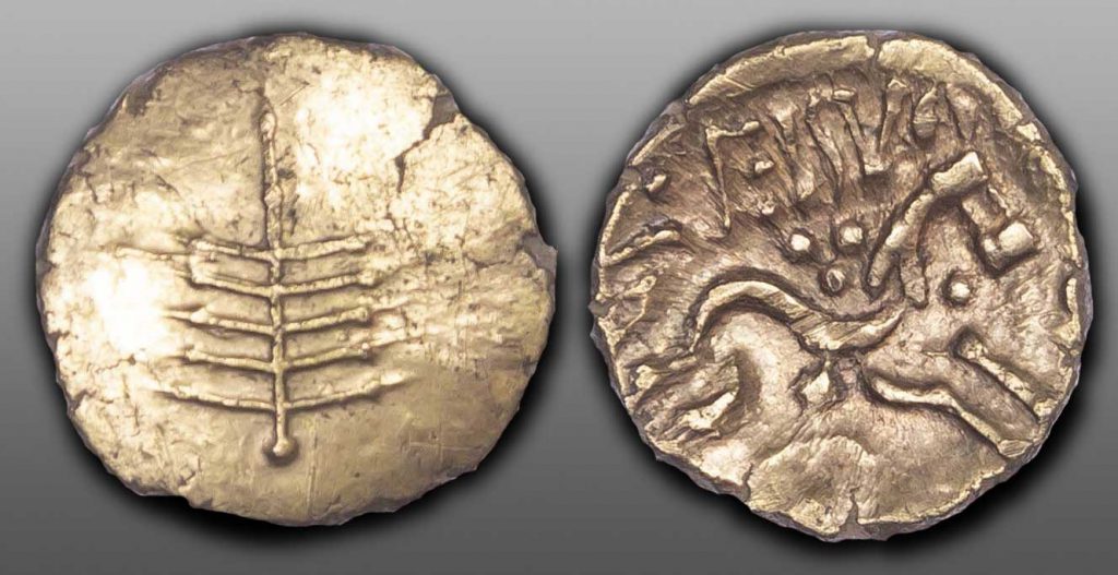
Dobunnic emblem made up of tree-like object with ten branches
Celticized horse right, legend above, spoked wheel below.
Successor to the united Dobunnic throne following the re-merger of the tribe by Anted[…]. He came to power around 30AD, and was probably chieftain during the invasion campaigns of Plautius, though whether he was leader of the faction of the Dobunni that surrendered to Plautius at Durovernon is unknown.
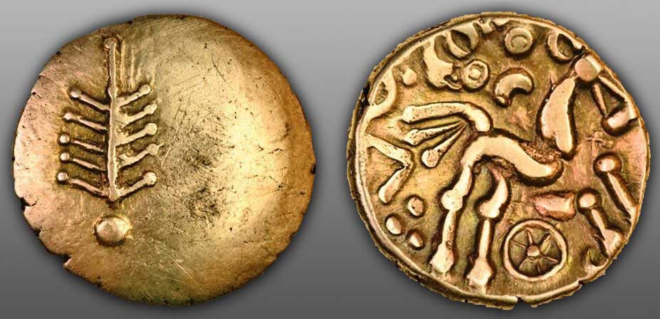
Inam[…] – Dobunni King
Dobunnic emblem made up of tree-like object with ten branches
Celticized horse right, legend above, spoked wheel below.
Appeared to rule over the entire Dobunnic territory. Whether he ruled the kingdom prior to it being divided and shared by Bodvoc and Corio or after the tribe was reunited under the kingship of Anted[…], will probably never be known with any certainty.
Bodvoc – Northern Dobunni King
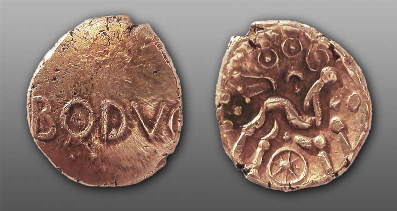
Issued coin during the last decades of the first century BC. It is probable that he ruled over the northern part of the Dobunni tribe, as all of his coins have been found in that region, his contemporary, Corio appeared to have ruled over the southern part of the tribe, though some of his coins have been found in the northen territory. Whether the division of the Dobunnic kingdom was an amicable arrangement between two legitimate sons of the old king or was the result of an internecine war between members of opposing noble families, will probably never be known. Coinage distribution evidence shows that Corio possibly ruled over the entire Dobunnic kingdom for a while at least, before Bodvoc took over in the north. It is possible that Bodvoc was succeeded by Catti[…] in the north, while Corio was replaced by Comux[…] in the southern territories. A variant of his name may have been Bodvoccus or Boduoccus.
Corio – Southern Dobunni King
Tree-like emblem with Ten Branches,
rev. co[rio], triple tailed horse right, above and wheel below, symbols in fields
King of the southern Dobunni in Gloucester towards the end of the first century BC. Although his coins are found throughout the Dobunnic territories, they are clustered mainly in the south, while the northern lands appeared to have been under the control of another Dobunnic overlord, Bodvoc, who issued his own coins. It is possible that the splitting of the Dobunnic territories occurred during his reign. Corio was succeeded at around the turn of the millennium by Comux[…].
Catti[…] – Northern Dobunni King
Dobunnic tree-like emblem
Celticized triple-tailed horse right, spoked wheel below, legend above
Possibly inherited the northern Dobunnic lands from Bodvoc around the turn of the millennium, therefore contemporary with Comux[…] who appeared to have succeeded Bodvoc’s old rival Corio in the southern territories of the Dobunni.
Comux[…] – Southern Dobunni King
tree symbol,
rev. comvx, triple-tailed horse right, six-spoked wheel below
Possibly succeeded Corio as the king of the southern Dobunnic territories around the turn of the millennium, therefore contemporary with Catti[…] who inherited the northern Dobunnic kingdom from Bodvoc.
References for The Dobunni
- The Geography of Claudius Ptolemaeus, trans. by E.L. Stevenson (Dover, New York, 1991);
- Atlas of Great Britain by the Ordnance Survey (Country Life, 1982);
- Historical Map and Guide: Roman Britain by the OS (4th Ed., 1990);